Drone Services North East

Surveying & Mapping

certified · Fully insured · CAA-compliant

We provide professional drone surveying and mapping services that deliver centimetre-accurate geospatial data for engineering, construction, and land management. Using RTK/PPK-enabled drones and ground control points, we produce orthomosaics, digital elevation models, and 3D point clouds that meet industry standards for precision and reliability.


Our outputs integrate seamlessly with CAD, GIS, and BIM workflows — supporting volume calculations, cut/fill analysis, topographic surveys, and as-built verification. Every project follows rigorous quality assurance protocols, with full metadata, accuracy reports, and coordinate system documentation to ensure your data is fit for technical use and regulatory compliance.

Professional Drone Surveying & Mapping for Engineering Accuracy

Our Surveying & Mapping service delivers centimetre-accurate geospatial data using RTK/PPK drone technology and ground control points — producing orthomosaics, digital elevation models (DEMs), and 3D point clouds that meet rigorous engineering and surveying standards.

We go beyond basic aerial photos to provide metrically precise, georeferenced datasets that integrate directly into CAD, GIS, and BIM workflows. Every project includes full metadata, coordinate system documentation, and quality assurance reporting so you can trust the data for technical decision-making.

Our methodology ensures: Sub-5cm horizontal and vertical accuracy with ground control, compliance with national mapping standards, seamless export to industry-standard formats (LAS, GeoTIFF, DXF), and full auditability through comprehensive accuracy statements and processing logs.

Whether you need topographic surveys, volumetric calculations, cut/fill analysis, or as-built verification — our deliverables are engineered for precision, reliability, and immediate use in professional design and planning environments.

Why Professional Surveying Matters

Centimetre-Level Accuracy

Unlike standard drone operators, we use RTK/PPK-enabled drones with ground control points to achieve survey-grade accuracy (2–5cm) — suitable for engineering design, legal boundaries, and regulatory submissions.

Industry-Standard Deliverables

All outputs are delivered in native CAD and GIS formats — including LAS point clouds, GeoTIFF DEMs/DSMs, DXF/DWG contours, and shapefiles — ready for direct import into AutoCAD, Civil 3D, ArcGIS, QGIS, and more.

Full Quality Assurance

Every survey includes an accuracy report, ground control log, processing methodology statement, and metadata documentation — ensuring full traceability and compliance with professional surveying standards.

Rapid Turnaround, Minimal Site Disruption

Cover large or complex sites in a fraction of the time of traditional surveying — with no need for personnel to traverse hazardous terrain, active earthworks, or live traffic zones.

Engineered for Technical Use

Data is processed using professional photogrammetry software (Pix4D, Agisoft) with rigorous QA checks — not consumer apps that produce visually appealing but metrically unreliable outputs.

What This Service Delivers

Topographic Surveys

Detailed terrain models capturing ground levels, features, and contours — compliant with national surveying standards and suitable for engineering design.

Deliverables include:

  • Digital Terrain Model (DTM) with ground-only elevation
  • Digital Surface Model (DSM) including vegetation and structures
  • Contour lines (0.1m, 0.5m, 1m intervals)
  • Spot height grids and feature extraction (manholes, kerbs, trees)
  • Orthomosaic base map (2–5cm GSD)
  • Coordinate system: OSGB36, ETRS89, or client-defined

Accuracy: ±2–5cm horizontal and vertical with ground control points; ±10–30cm without (GCP-free option available).

Applications: Civil engineering design, drainage planning, flood risk assessment, planning applications, site feasibility studies.

Volumetric & Earthworks Analysis

Precise volume calculations for stockpiles, cut/fill areas, and excavation progress — enabling accurate resource tracking and cost control.

Capabilities:

  • Stockpile volume (individual or grouped)
  • Cut and fill analysis against design surfaces
  • Progress tracking between survey dates
  • Volume change reports with % variance
  • Exportable CSV tables and 3D comparison maps
  • Integration with earthworks management software

Accuracy: Volumes typically within 1–3% of ground truth when GCPs are used and surfaces are well-defined.

Applications: Quarry and landfill management, construction earthworks, mining operations, agricultural silage storage, port bulk handling.

Orthomosaic Mapping

High-resolution, distortion-free aerial maps with true scale and georeferencing — ideal as a base layer for design, planning, and asset management.

Specifications:

  • Ground Sample Distance (GSD): 1cm to 10cm (client-defined)
  • Georeferenced to national or local coordinate systems
  • Seamless, colour-balanced mosaic with minimal shadows
  • GeoTIFF format with world file (.tfw) or embedded georeference
  • Optional KML overlay for Google Earth
  • Compatible with all major GIS and CAD platforms

Quality control: Radiometric calibration, lens distortion correction, and tie-point validation ensure geometric integrity.

Applications: Site planning, environmental monitoring, utility corridor mapping, agricultural zoning, historical record archiving.

3D Point Clouds & Mesh Models

Dense 3D representations of terrain and structures for visualisation, measurement, and modelling in engineering and BIM environments.

Outputs include:

  • LAS/LAZ point clouds (classified or unclassified)
  • Textured 3D mesh models (OBJ, FBX, 3DS formats)
  • Point density: 100–500+ points/m²
  • RGB colourised or intensity-based rendering
  • Coordinate system embedded in metadata
  • Decimated versions for web or mobile viewing

Processing: Generated via professional photogrammetry software with noise filtering, outlier removal, and surface reconstruction.

Applications: BIM clash detection, heritage recording, structural deformation analysis, virtual reality walkthroughs, engineering simulation inputs.

As-Built & Verification Surveys

Post-construction verification that built works match design intent — supporting handover, compliance, and dispute resolution.

Deliverables:

  • Comparison overlays (design vs. as-built)
  • Deviation heatmaps and cross-sections
  • Feature extraction (kerb lines, building footprints, pipe runs)
  • PDF report with key findings and tolerances
  • Raw data archive for independent review
  • Metadata package for audit trail

Standards alignment: Can be tailored to RICS, ICE, or client-specific verification protocols.

Applications: Highway handover, rail infrastructure verification, building completion certification, utility installation validation, warranty evidence.

How It Works

From project briefing through to final delivery, every survey follows a rigorous geospatial workflow designed to deliver centimetre-accurate, engineering-grade data ready for CAD, GIS, and BIM integration.

1
2
3
4
5
1

Project Briefing & Accuracy Requirements

We begin by clarifying your survey purpose, required accuracy, coordinate system, and intended use — whether for design, volume calculation, or regulatory submission.

This stage includes:

Survey objective definition (topo, volumetric, as-built), accuracy tolerance specification (e.g., ±3cm), coordinate system requirements (OSGB36, ETRS89, local grid), area of interest boundary confirmation, and deliverable format needs (LAS, GeoTIFF, DXF).

2

Ground Control & Flight Planning

Precise flight paths are designed alongside ground control point (GCP) placement to ensure optimal coverage and metric accuracy for your specific terrain and features.

Planning considerations:

GCP number and distribution strategy, RTK/PPK base station setup (if used), flight altitude and overlap settings (typically 80% front / 70% side), weather and lighting window selection, airspace permissions and NOTAM checks.

3

Field Data Capture

Survey-grade drone flights are conducted using calibrated RTK/PPK systems, with GCPs surveyed in using GNSS rovers to establish precise ground truth.

Operational standards:

GNSS rover survey of all GCPs (±1–2cm accuracy), drone calibration and lens verification, systematic flight execution with real-time telemetry monitoring, image quality validation on-site, full metadata logging (camera, position, time).

4

Photogrammetric Processing

Raw imagery and GCP data are processed in professional software (Pix4D or Agisoft) to generate accurate, georeferenced outputs with full quality assurance.

Processing workflow:

Image alignment and bundle adjustment, GCP-based georeferencing and error minimisation, dense point cloud generation, DTM/DSM extraction, orthomosaic creation with radiometric correction, accuracy validation against check points.

5

Delivery & Integration Support

Final datasets are delivered in your required formats with comprehensive documentation — ready for immediate use in engineering, planning, or asset management systems.

Deliverables include:

Accuracy report with RMSE values, processing methodology statement, LAS point cloud, GeoTIFF DEM/DSM/orthomosaic, DXF/DWG contours or features, shapefiles, KML overlays, and raw data archive (optional).

Typical Applications

Centimetre-accurate drone surveying and mapping for engineering, construction, land management, and infrastructure projects — delivering geospatial data ready for CAD, GIS, and BIM workflows.

Topographic Surveys

Accurate terrain models with contours, spot heights, and feature extraction — compliant with national surveying standards for engineering design.

Volumetric Calculations

Precise stockpile, cut/fill, and earthworks volume measurements for resource tracking, cost control, and progress billing in quarries and construction.

Highway & Rail Corridors

Linear surveys for road widening, rail alignment, and drainage design — capturing ground levels, features, and vegetation encroachment.

Quarry & Mine Mapping

Regular site-wide surveys for reserve calculation, blast planning, haul road monitoring, and regulatory compliance in extractive industries.

Land Development & Planning

Baseline topography for feasibility studies, drainage strategy, and planning applications — with OSGB36 or local grid alignment.

Flood Risk & Drainage Modelling

High-resolution DTMs for hydraulic modelling, surface water management, and SuDS design — capturing subtle terrain gradients.

Agricultural & Estate Mapping

Field boundary mapping, soil erosion tracking, and silage clamp volume measurement for farm management and subsidy claims.

Engineering Design Support

Survey-grade base data for civil, structural, and environmental engineering — delivered in AutoCAD, Civil 3D, and Revit-compatible formats.

As-Built Verification

Post-construction validation of earthworks, structures, and utilities against design models — supporting handover and dispute resolution.

Utility Corridor Mapping

Accurate mapping of overhead lines, substations, and pipeline routes — including clearance heights and vegetation proximity.

Heritage & Archaeology Recording

Non-invasive 3D documentation of historic sites, earthworks, and scheduled monuments for conservation and research purposes.

BIM & Digital Twin Integration

Point clouds and mesh models formatted for clash detection, asset tagging, and lifecycle management in BIM environments.

Boundary & Legal Surveys

Supporting data for boundary disputes, easements, and land registry submissions — with full metadata and accuracy certification.

Dispute & Insurance Evidence

Time-stamped, georeferenced survey data for earthworks disputes, flood damage assessment, and insurance claims validation.

Progress Monitoring & Change Detection

Multi-temporal surveys to track site evolution, quantify earthmoving progress, and generate change heatmaps between phases.

GIS & Spatial Analysis

GeoTIFF, shapefile, and KML outputs ready for spatial querying, watershed delineation, viewshed analysis, and asset management systems.

Why Professional Surveying Matters

Many drone operators deliver visually appealing aerial photos with no geospatial accuracy, inconsistent scale, or audit trail. We provide survey-grade data — captured with ground control, processed to engineering standards, and delivered with full metadata and accuracy certification for technical use.

What Sets Us Apart

  • Centimetre-level accuracy, not just pretty pictures — verified with ground control points and RTK/PPK technology
  • Industry-standard outputs in LAS, GeoTIFF, DXF, and shapefile formats ready for AutoCAD, Civil 3D, ArcGIS, and QGIS
  • Full quality assurance documentation including accuracy reports, processing logs, and coordinate system statements
  • Rigorous methodology following national surveying best practices and photogrammetric validation protocols
  • Engineered for technical decision-making — trusted by civil engineers, quantity surveyors, and planning authorities

Who This Service Is For

Civil engineers, land surveyors, quantity surveyors, planning consultants, earthworks managers, and GIS professionals who require reliable, metrically accurate spatial data — not unverified drone imagery from general operators.

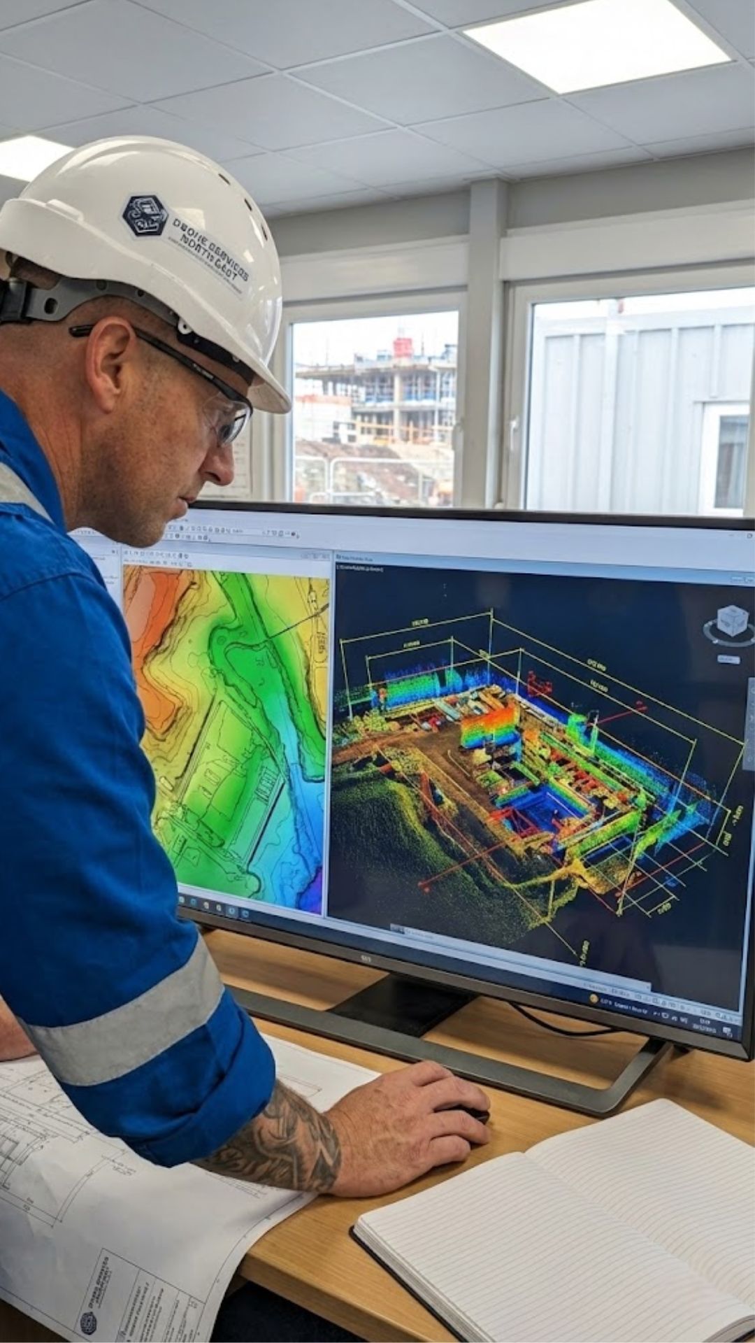
Surveyor reviewing centimetre-accurate drone-generated topographic map and point cloud data for engineering project

Frequently Asked Questions

Your questions about drone surveying, accuracy, and geospatial deliverables — answered.

How accurate is your drone surveying data?
With ground control points (GCPs): 2–5cm horizontal and vertical accuracy. Without GCPs (using RTK/PPK): 10–30cm. Every project includes an accuracy report with RMSE values and methodology documentation — meeting RICS and national surveying standards.
What file formats do you deliver for CAD/GIS teams?
We provide native industry formats:
Point clouds: LAS/LAZ
Elevation models: GeoTIFF DEM/DSM
Contours/features: DXF, DWG, shapefiles
Orthomosaics: GeoTIFF with world file (.tfw)
All data is georeferenced to your required coordinate system (OSGB36, ETRS89, local grid).
Do you use ground control points (GCPs)?
Yes — when high accuracy (<5cm) is required. Our surveyors place and measure GCPs using GNSS rovers (±1–2cm accuracy). For lower-accuracy needs (e.g., visual inspections), we use RTK/PPK drones without GCPs to reduce cost and time.
Can you calculate stockpile or earthworks volumes?
Absolutely. We generate precise volume reports for:
• Stockpiles (individual or grouped)
• Cut/fill areas against design surfaces
• Progressive earthmoving between survey dates
Accuracy typically within 1–3% of ground truth when GCPs are used. Deliverables include CSV tables and 3D comparison maps.
How do you ensure data quality and reliability?
Through rigorous QA:
• Pre-flight camera calibration
• GCP validation and tie-point density checks (>10,000/ha)
• Accuracy verification against independent check points
• Full processing logs (Pix4D/Agisoft)
• Metadata package with coordinate system and methodology statements
All outputs are audit-ready for engineering or legal use.
Can your data integrate with our BIM or asset management system?
Yes. We’ve delivered data compatible with:
BIM: Revit, Navisworks (via point clouds/meshes)
Asset systems: SAP, Maximo, GIS platforms
CAD: AutoCAD, Civil 3D, MicroStation
Just specify your system during scoping — we’ll match formats and coordinate systems.
What’s the difference between a DTM and a DSM?
DTM (Digital Terrain Model): Bare-earth elevation — removes buildings, vegetation, and structures. Used for drainage, flood modelling, and earthworks.
DSM (Digital Surface Model): Includes all surface features (trees, buildings, equipment). Used for viewshed analysis, solar potential, and as-built verification.
We can deliver both from the same flight.
How quickly can I get survey deliverables?
Standard turnaround:
Basic orthomosaic: 24–48 hours
Full topo survey (with contours): 3–5 working days
Volume reports: 2–3 working days
Complex projects (e.g., large-scale DTMs) may require 7–10 days — confirmed during scoping.
Do you support legal or boundary surveys?
We provide supporting geospatial data for boundary disputes, easements, and land registry submissions — including:
• High-resolution orthomosaics with scale certification
• Feature extraction (fences, walls, kerbs)
• Accuracy reports and metadata
Note: Final legal boundaries must be certified by a chartered land surveyor — we complement their work with aerial context.
Can you survey large or complex sites (e.g., highways, quarries)?
Yes. We regularly map:
• Linear corridors (roads, rail, pipelines)
• Active quarries and mines
• Airports and port facilities
• Flood plains and conservation areas
Using systematic flight planning, we cover 100+ hectares in a single day — with no disruption to operations.

Ready to Get Started?

Discuss Your Surveying Requirements

We'll advise on the most effective approach for your project — from accuracy specifications and ground control planning through to CAD/GIS-ready deliverables.

Same-day response · No-obligation consultation

Survey-Grade Outputs
£10M Insured
CAA Compliant
HSE Experienced