Professional Drone Services
HSE-Led Aerial Operations for Construction, Energy & Industrial Sectors
Who We Are
We operate aerial drones across construction, energy, and industrial sectors — but we're not photographers. We're HSE professionals who use drones as precision tools to solve real operational challenges.
- Engineering-grade data (2-5cm)
- Full RAMS & Safety Integration
- Documented compliance workflows
- £10M Insurance Coverage
- NEBOSH-qualified leadership
- Construction site fluency
- Onshore & Offshore capable
- 48-hour turnaround
North East England & Beyond
Based in the North East but operating across the UK and North Sea. £50M+ developments, renewable energy, high-consequence industrial sites.
NEBOSH Qualified HSE Advisor
Principal Contractor experience on major construction projects. Every flight plan is personally reviewed by Peter to ensure your compliance and safety.
Coverage & Leadership
Sector Experience:
- Large Construction Developments Inspections, progress documentation, stockpile surveys
- Energy & Renewables Wind assets, solar farms, electrical infrastructure
- Industrial & Critical Infrastructure Plants, pipelines, rail, utilities
- Live Environments Operations where downtime is not an option
NEBOSH-qualified Health & Safety Advisor
Principal Contractor experience on major construction and energy projects • HSE-level risk management • 15+ years operational safety
Philosophy:
- Safety First Every operation planned, reviewed and signed off — safety before capability
- Compliance Embedded PDRA01, PTW, RAMS — institutional rigour from first mission
- Site Integration We speak construction. We fit your systems, not the reverse
The Problem
When you hire operators without construction or HSE experience, you're not just getting lower quality—you're assuming operational, compliance, and financial risk. Here's what goes wrong:
- No Safety Culture Missing PTW, RAMS, method statements — gaps in your audit trail
- Untrained on Hazards Can't recognize site-specific risks or environmental hazards
- Doesn't Speak Construction No understanding of critical path, SIMOPS, or exclusion zones
- Non-Compliant Integration Can't plug into your HSE, QA, or permit systems
- Poor Quality Deliverables Folders of raw JPEGs instead of engineered inspections, annotated orthomosaics, or progress reports
- Unplanned Re-Flights Poor planning means multiple mobilisations, not one professional job
- Project Delays Site shutdowns while you wait for re-shoots or clarifications
- Hidden Compliance Costs Regulatory follow-ups, insurance issues, HSE inquiries
How It Works
We conduct a comprehensive pre-flight planning phase led by Peter Regan, our NEBOSH-qualified HSE Advisor. This includes site-specific risk assessments, airspace coordination, CAA notifications, method statements and full alignment with your systems.
We brief your entire team, establish communication protocols, coordinate with other trades (SIMOPS), define exclusion zones and integrate fully into your site safety systems and workflows.
Structured, engineered outputs: Orthomosaics, inspection reports with annotations, progress documentation, data sets and media. All documented with safety sign-offs and aligned to your project records.
The PDRA01 (Permit & Drone Risk Assessment) is a structured, multi-section checklist that ensures every operation is planned with safety, compliance and liability in mind. Here's what happens:
- Location, grid reference, classification
- Site contact & responsible persons
- Site-specific hazards & exclusion zones
- Site rules & PPE requirements
- Aircraft type & registration numbers
- Altitude, flight area & duration
- Weather limits & environmental checks
- Operator qualifications & insurance
- Hazard identification (P-I matrix)
- Mitigation measures & contingencies
- SIMOPS coordination & interfaces
- Emergency response procedures
- Site Manager approval & sign-off
- Emergency contact confirmation
- Conditional approvals or restrictions
- Insurance & indemnity verification
On the day of operations, we integrate seamlessly into your site environment. We don't operate in isolation—we're part of your team.
- Crew safety induction & site rules
- Hazard review & exclusion zones
- Emergency procedures & rally points
- Communication protocol confirmation
- Real-time coordination with other trades
- Exclusion zone management & spotters
- Live site conditions assessment
- Approval gates before every flight
- Continuous weather monitoring
- Real-time hazard management
- Communication with site control
- Data collection & quality checks
- Site manager sign-off confirmation
- Data integrity & completeness check
- Any issues or follow-up actions noted
- Timeline for deliverables confirmed
Professional outputs delivered within 24–48 hours. Not folders of images—structured, engineered data ready for decision-making and integration into your project records.
- Annotated orthomosaics with measurements
- Condition assessments & defect mapping
- Professional layout & branding
- Site manager sign-off integration
- High-resolution orthomosaics & DEMs
- Raw image datasets & metadata
- GeoTIFF & Shapefile formats
- GPS coordinates & spatial references
- Flight logs & operational records
- Safety sign-offs & approvals
- Data chain of custody documentation
- Insurance & liability confirmations
- Progress photography (4K where specified)
- Structured progress reports
- Executive summaries for stakeholders
- Custom analysis based on objectives
Planning & Compliance
Before a single rotor spins, we conduct a comprehensive Permit to Work (PTW) and Risk Assessment. This isn't bureaucracy — it's the difference between a safe operation and a site incident.
Our Planning Process Includes:- PDRA01 Risk Assessment Site-specific hazard identification and mitigation.
- Airspace Coordination CAA notifications, airspace classification checks, NOTAMs.
- On-Site Surveys Ground walk-throughs, exclusion zone mapping, emergency procedures.
- Personnel Briefings Safety inductions for all crew and site contacts.
- Insurance Verification Confirmation of coverage and indemnity requirements.
The PDRA01 (Permit & Drone Risk Assessment) is a mandatory pre-flight checklist. Led by Peter Regan, our NEBOSH-qualified HSE Advisor, it covers:
- Location & Grid Reference
- Contact & Responsible Persons
- Site Classification & Hazards
- Aircraft Type & Registration
- Altitude & Flight Area
- Weather Conditions & Limits
- Hazard Identification (P-I Matrix)
- Mitigation Measures
- SIMOPS & Exclusion Zones
- Site Manager Sign-Off
- Emergency Contact Details
- Conditional Approvals / Restrictions
Every PDRA01 assessment is personally reviewed and signed by Peter Regan. His construction and safety expertise ensures your site compliance, insurance validity, and operational safety.
Zero Shortcuts No flight proceeds until the PDRA01 is signed off. Every site gets the same rigorous assessment, whether it's a small residential survey or a £50M industrial project.
Real-World Scenarios
An unvetted operator flies without coordination. SIMOPS gap causes site evacuation, £50k/day shutdown.
Pre-flight coordination with your Site Manager. Exclusion zones briefed, SIMOPS documented, operations seamless.
Unlabelled JPEGs instead of reports. Can't measure, can't integrate to CAD, re-flight required = double spend.
Engineering-grade deliverables. Point clouds (LAS), orthomosaics, annotated reports ready for CAD/BIM integration.
Uninsured operator incident. Your company liable for £500k+ claims, audit failures, project shutdown.
£10M insurance + documented compliance. Peter reviews every flight, PDRA01 signed off, full audit trail for compliance.
Leadership

Peter holds NEBOSH and environmental qualifications and extensive Principal Contractor HSE Advisor experience on major construction sites. His knowledge ensures your compliance and safety.
Safety & Construction
- Principal Contractor Complex construction HSE.
- NEBOSH Construction Site management safety.
- NEBOSH Process Safety High hazard industrial.
Aviation & Environment
- CAA Certified A2 CofC & GVC.
- IEMA Certified Environmental compliance.
- Offshore Survival BOSIET/GWO/HUET.
Services (1/2)
Structured aerial data capture delivering clear imagery, measurements, and professional reports for technical review and decision-making.
What You Receive:- Point Clouds (LAS/LAZ) High-density 3D data for CAD/BIM.
- Orthomosaic Imagery Georeferenced site maps.
- Surface Models DTM/DEM for elevation analysis.
Scheduled aerial oversight supporting progress tracking and stakeholder visibility — without putting people at height or disrupting work.
What You Receive:- Progress Documentation Weekly/Monthly PDF reports.
- Timestamped Imagery Evidence for dispute resolution.
- Volume Change Reports Cut/fill analysis for earthworks.
Non-intrusive inspections of structures and assets — reducing working-at-height risks while capturing visual and thermal data.
What You Receive:- Defect Reports PDFs with severity ratings (RAG).
- Annotated Imagery Tagging of cracks, corrosion, defects.
- Thermal Analysis Heat loss, moisture, overheating.
Services (2/2)
Accurate aerial surveys delivering professional outputs suitable for engineering, planning, and site analysis workflows.
What You Receive:- Contour Plans (DXF/DWG) Ready for AutoCAD/Civil 3D.
- Point Cloud Data Dense 3D terrain representation.
- CAD-Ready Files Cleaned data for engineering use.
Drone operations for offshore, coastal, and renewable environments — planned around safety protocols for complex industrial sites.
What You Receive:- Condition Assessment Detailed reports on asset health.
- Blade Inspection High-res imagery of leading edges.
- SIMOPS Documentation Safe ops alongside marine traffic.
High-quality aerial photography and video for commercial, property, and promotional use — capturing scale and impact from the air.
What You Receive:- 4K Video & Photography Broadcast-quality footage.
- Social Media Content Edits for Instagram/LinkedIn.
- Branded Materials Assets with your logos/overlays.
Professional Deliverables
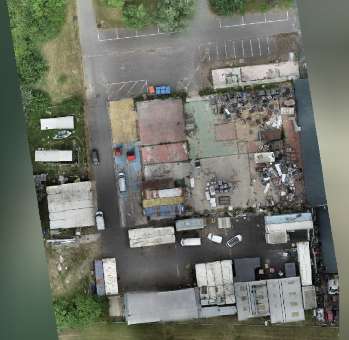
Seamless aerial image mosaic for site mapping.
- Site mapping & planning
- Progress documentation
- GIS integration
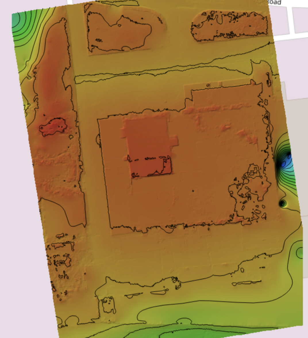
Topographic maps for terrain analysis.
- Civil engineering design
- Drainage analysis
- Site grading
Advanced 3D & Point Cloud Data
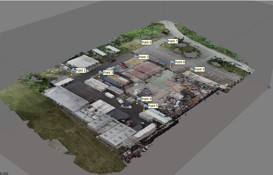
Textured 3D mesh for visualization.
- Building inspection
- Infrastructure assessment
- Volume calculations
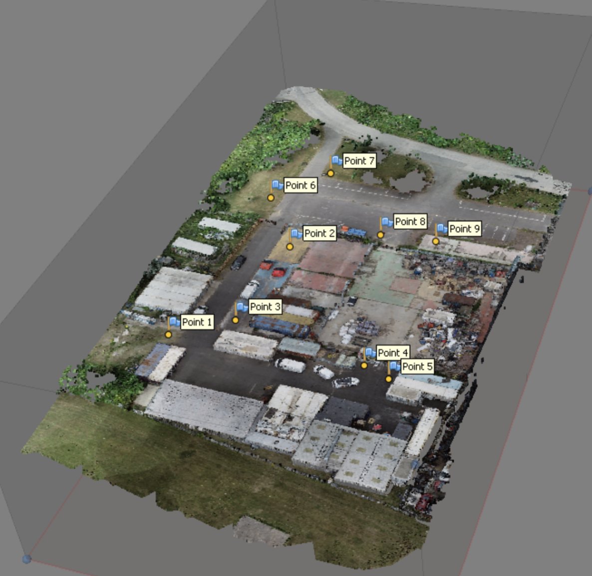
High-density points with 2-5cm accuracy.
- Surface analysis
- Change detection
- CAD integration
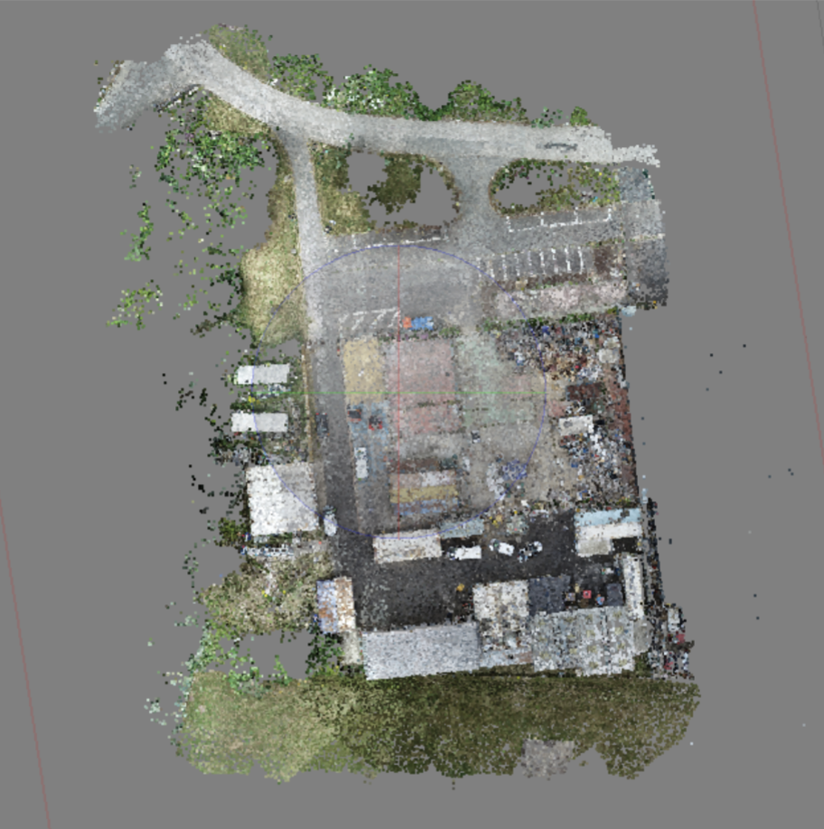
Feature points for alignment validation.
- Camera alignment
- GCP accuracy check
- Processing QA/QC
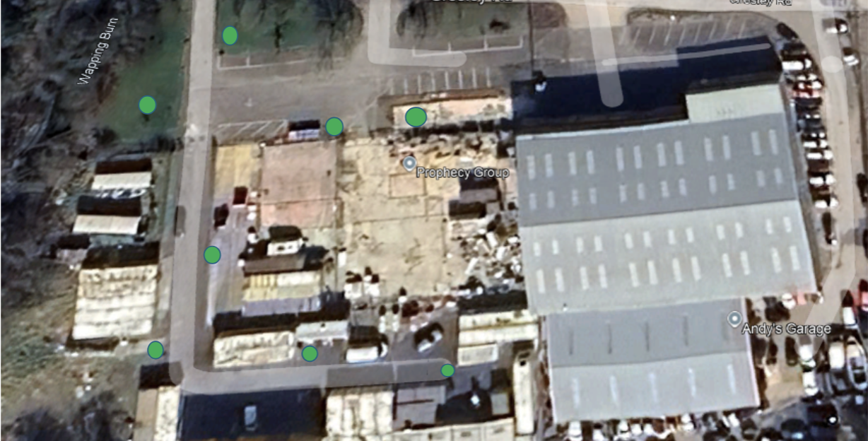
RTK/DGPS surveyed control points.
- Grid reference assignment
- Coordinate alignment
- Professional surveying
Elevation & Terrain Models
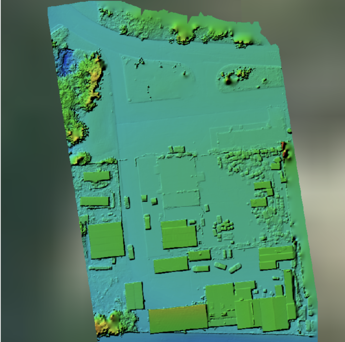
All surfaces including buildings & vegetation.
- Volume calculations
- Site visualization
- Flood analysis
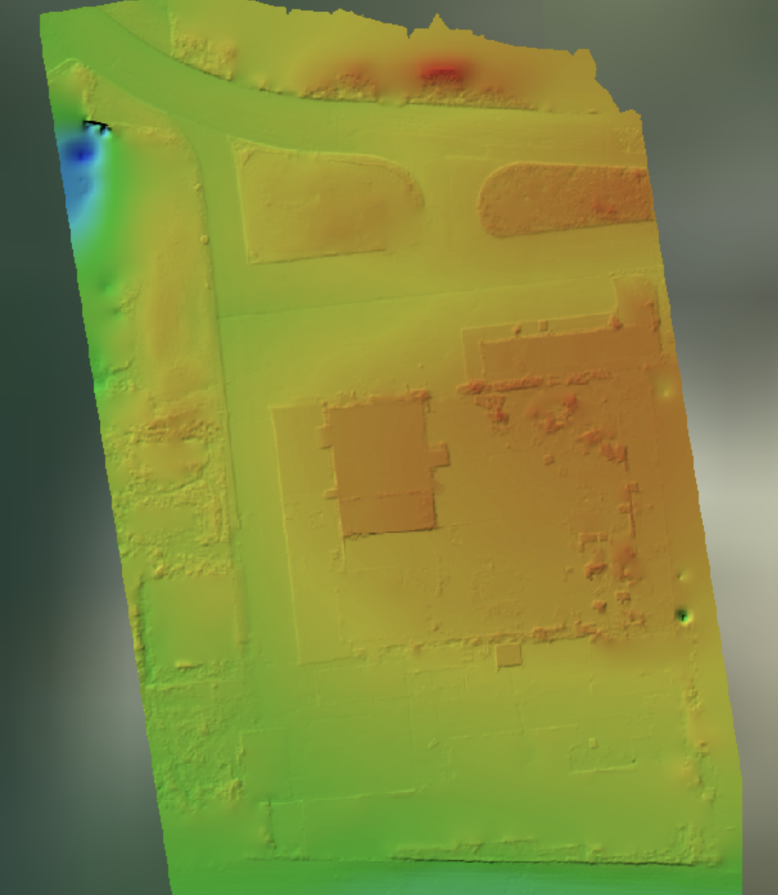
Bare-earth terrain without obstructions.
- Contour generation
- Civil engineering
- Baseline surveys
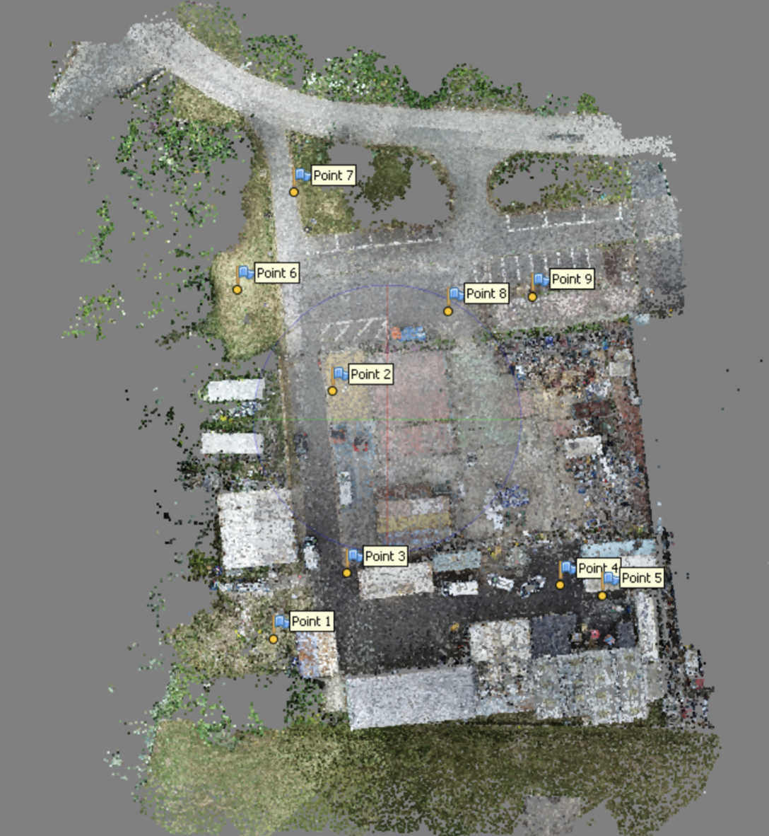
Surveyed control points for accuracy.
- Accuracy validation
- GIS integration
- Professional surveys
UK National Grid (OSGB36) or international systems.
GeoTIFF, LAS, E57, OBJ, FBX, PDF, DWG.
Ground truth validation, full QA/QC documentation.
Key Sectors
From groundworks to handover.
- Main Contractors & PCs
- Civil Engineering Firms
- Property Developers
Maximizing asset uptime through efficient inspection.
- Offshore Wind Farms
- Solar Installations
- Power Generation Plants
Reducing shutdown times in COMAH environments.
- Refineries & Chemical
- Process Industries
- Manufacturing Plants
Full lifecycle monitoring.
Turbine inspections & coordination.
Stack and confined space inspections.
The Advantage
Case Study 01
Client required engineering-grade accuracy for roof refurbishment planning and volume stockpile calculations.
The catch: 8,540m² live manufacturing facility with zero operational downtime tolerated. Traditional surveying would require site shutdowns.
Deployed RTK drones with Ground Control Points
- Coordinated flight paths around shift changes & crane ops
- Processed raw imagery into point clouds & orthomosaics
- Delivered within 48 hours of final flight
- Provided engineering-grade accuracy report
Client successfully tendered for refurbishment works using drone data alone. Zero site visits required.
Operations maintained at 100% uptime throughout survey period.
Key Takeaway: By removing the need for site shutdowns and traditional surveying schedules, drone operations compressed a 3-week project into 1 week while maintaining full production. The data quality enabled immediate tender release without costly re-surveys.
Case Study 02
Blade inspections urgently required on North Sea offshore turbines.
Traditional rope access method would require: specialist teams, vessel booking, weather windows, working-at-height risk, and significant cost per turbine.
Deployed Thermal + Visual drone teams via CTV
- Managed SIMOPS with marine traffic & helicopter routes
- Captured high-res visual of blade edges, tips & receptors
- Thermal imaging for structural anomaly detection
- Delivered annotated defect report within 72 hours
Inspection completed in 1/10th the time. Zero working-at-height hours. Full defect identification with actionable intelligence.
Data now integrated into asset management system for trend analysis.
Key Takeaway: Drone operations eliminated the vessel cost, working-at-height risk, and weather delays. What would have been a 2-week project with rope access was delivered in 2 days. The thermal + visual data combination provided superior defect identification compared to traditional methods.
Testimonials
We brought Drone Services North East in to support progress monitoring on a live construction site. What stood out straight away was the planning and safety side — RAMS, permits and site coordination were handled properly, which meant no disruption to our programme. The data was clear, accurate and genuinely useful for reporting and internal reviews.
Accessing certain areas safely has always been a challenge for us. Using drones meant we avoided working at height altogether. The inspection report was well structured, clearly annotated and easy to share with our engineering team. It's the first time drone data has actually fitted into our existing processes.
From a health and safety point of view, this was handled properly. Risk assessments were site-specific, the team integrated well with our supervisors, and there were no surprises. It felt like working with someone who understands construction sites, not just drone flying.
The drone inspections allowed us to assess asset condition quickly without shutting down operations. Communication was clear, safety controls were robust, and the final report gave us exactly what we needed to plan the next phase of work. We'd use this approach again without hesitation.
Safety & Compliance
Our operations follow structured health & safety procedures, quality checks, and regulatory compliance processes. Every person, every flight, every project adheres to the same professional standards.
- NEBOSH General Certificate – Construction HSE competency
- NEBOSH Fire Certificate – Fire safety & risk management
- NEBOSH Construction Certificate – Site-specific H&S expertise
- NEBOSH Process Certificate – Process safety & hazard management
- SMSTS Certified – Site management safety training
- CAA A2 Certificate of Competence – Advanced drone operations
- CAA General Visual Certificate – Airspace & regulatory compliance
- IEMA Environmental Certificate – Environmental impact assessment
- Documented RAMS / SSOW processes – Site-safe working procedures
- FPV UK Member – Professional drone operator standards
Covers all operations on site. Full documentation and certificate of currency provided before every project.
Coverage for professional liability, data accuracy, and delivery obligations. Your protection is our responsibility.
Trusted by major contractors and recognized by leading industry bodies:


✓ Regulatory Confidence
Your supply chain is protected. CAA compliant, fully documented, and fully insured. Auditors sign off. HSE accepts our work.
✓ Safety Culture
NEBOSH-qualified leadership means every operation is safety-first. We identify hazards you might miss and mitigate proactively.
✓ Quality Assurance
Standard operating procedures. Documented workflows. Your data meets professional and legal standards.
✓ Zero Hidden Risk
Full transparency on qualifications, insurance, and operational standards. No surprises. No gaps. No liability exposure.
Get Started
We've streamlined our engagement process to be transparent, efficient, and hassle-free. Most clients move from first contact to deployment within 5-7 business days. No long sales cycles. No pressure. Just professional drone services delivered safely.
We understand your scope, location, risk profile and specific deliverables. Usually a 15-minute call.
• Site location & site name
• Aerial photography, surveying, or inspection?
• Any safety hazards or access constraints
• Timeline and budget range
We assess airspace, ground hazards, permit requirements and safety considerations. Fixed-price proposal with no hidden costs.
• Airspace restrictions & flight paths
• CAA permits or exemptions needed
• Weather windows & optimal timing
• Risk assessment & safety protocols
We arrive site-ready, brief your team, coordinate all activities, capture data, and deliver professional outputs.
• Pre-flight safety briefing
• Raw imagery + processed deliverables
• Full compliance & incident documentation
• Ongoing support for questions
No surprises. No hidden costs. What we quote is what you pay.
Every operation meets UK airspace & safety regulations.
You're fully covered with our comprehensive liability insurance.
Ready to Deploy?
Contact our operations team to discuss your project and get a quote within 24 hours.
Ready to Deploy?
Get in touch with our operations team to discuss your project and receive a detailed quote.
- CAA Certified Full regulatory compliance & airspace clearance
- NEBOSH Qualified Team HSE expertise on every mission
- £10M Liability Insurance Complete project protection
- Fixed Transparent Pricing Zero hidden costs
- Professional Deliverables Orthomosaics, surveys, annotated reports
- Site-Ready Operations Integrated with your safety protocols
- Documented QA & Environmental Controls Quality and environmental procedures
- Offshore Capability IMCA-aligned marine operations